


A heat warning for most of southern Ontario, including ÎÚÑ»´«Ã½, is expected to come to a cool end Wednesday.Â
Environment Canada says a cooler and less humid air mass will move through the province, bringing much needed relief amid the multi-day heat wave.Â
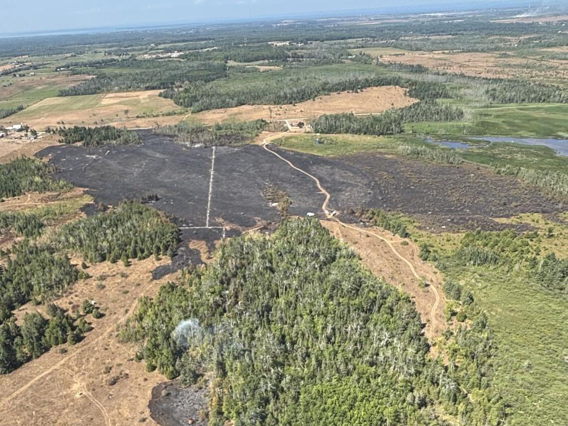
The cooler forecast also comes as wildfires burn in parts of the province, notably in the region around Kawartha Lakes, which reported one of blazes its battling grew rapidly from five to 33.5 hectaresÌý°Õ³Ü±ð²õ»å²¹²â.
Wednesday’s forecast
ÎÚÑ»´«Ã½nians will have to endure one final stretch of , as Wednesday is expected to bring a high of 30 C — feeling like 38 with humidity — before getting a taste of relief.
The afternoon will mainly be cloudy, with a 40 per cent chance of showers and risk of thunderstorm carrying over from Tuesday night.Â
Don’t let the clouds deceive you; grab your sunscreen as today’s UV index is expected to reach a high 7.Â
We will see the start of that cold air mass coming through Wednesday night as temperatures plunge to a low of 19 C, with rain clearing up in the evening as well.Â
This week’s forecast
Thursday marks the first full day post-heat warning, with a daytime high of 28 C, feeling more like 31 with humidity, and a UV index of 8. Expect clear skies and a low of 19 C in the evening.Â
However, temperatures are expected to spike again later in the week. On Friday, expect a sunny 30 C with a night time low of 21 C.
“It’s definitely possible we could be back in the warning this weekend. It might even be confined to just sort of the urban area of southern Ontario,” said Environment Canada meteorologist Crawford Luke.
The heat will continue into Saturday, with a sunny daytime high of 32 C. Though don’t fret yet, as a 40 per cent chance of showers and a 20 C evening low could squash the risk of a repeated heat event.Â
Then comfortable temperatures will really arrive.Â
Daytime highs are expected to plummet Sunday, with a daytime high of 23 C and an evening low of 15 C. A 40 per cent chance of rain will carry into Sunday as well. Luke said this is the day that will make or break a heat warning in the GTA, as any delay in Sunday’s expected cold front could create conditions considered a ‘heat event.’Â
Next week will start with a mix of sun and cloud and a Monday high of 22 C and nighttime low of 15 C.Â
All that is forecasted so far for Tuesday is a high of 25 C, continuing the trend of more comfortable days in the GTA.Â
What about air quality?Â
Wildfires across Canada have kept air quality in a state of limbo in the GTA. However, a decrease in humidity across Ontario could bring improvements.
IQAir forecasts ÎÚÑ»´«Ã½’s air quality to hover between “good” and “moderate” levels throughout the week.
Luke said smoke from the Kawartha Lakes fires is unlikely to reach ÎÚÑ»´«Ã½, but a change in wind direction could always send more smoke our way from larger fires in Manitoba and northern Ontario.Â
“We might notice a bit of haze or smoke tonight, tomorrow, but it should not be anything severe, like we’ve seen at other points this summer,” he said.Â
Not only can a decrease in smoke increase air quality, but a break from this summer’s back to back heat events could provide relief to many people who experience heat-related health struggles.
“Take action to protect yourself and others — extreme heat can affect everyone’s health. Determine if you or others around you are at greater risk of heat illness. Check on older adults, those living alone and other at-risk people in-person or on the phone multiple times a day,” Environment Canada’s heat warning stated.


To join the conversation set a first and last name in your user profile.
Sign in or register for free to join the Conversation